
 How to resolve AdBlock issue?


 Finding ways to spend time outdoors in the sweltering July temperatures can be challenging. Fortunately, for those intent on enjoying nature despite the heat, the Cape Fear River Trail boasts long stretches of paved, shady walkways. It’s a 7-mile long, one-way trail that stretches between the Jordan Soccer Complex at the north end, and the PWC Hoffer Water Plant on the south end. In-between you’ll find a variety of terrains. Some areas are hilly, while others are relatively flat. And while the trail isn’t usually crowded, if you don’t cross paths with fellow visitors, you will encounter an array of native wildlife.
Denise Brown, Park Ranger Supervisor at the Clark Park and Nature Center hopes locals will imbibe these natural charms when they visit.
“I was drawn to this job because of my passion for both museums and the outdoors. I love working with people and seeing people enjoying nature and learning," Brown said.
She said that visitors seem to love the immersive feeling of the trail.
“I consider some of the highlights to be the paved trail that makes the trail accessible, the shade throughout, the mountain biking trails, and the fact that the natural surrounding makes you feel like you are immersed in nature and not in the middle of the city.”
This trail is uniquely positioned as a place of respite because it’s accessible without compromising tranquility.
Community members agree. Local running enthusiasts, Joshua and Maggie, said they visit the trail several times a month and sometimes bring their 14-month-old along in his stroller. Maggie described the trail saying, “Half is hilly and half is flat. That's nice for planning a run. You can start at the ball fields and run the hilly section, or you can start at the park and run the flatter part.
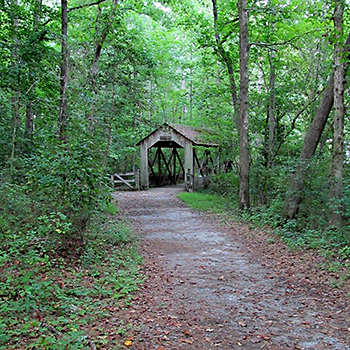
“The flatter part goes from the park out to the river and there is a small waterfall and a covered area alongside the river in view of a trestle bridge. I've seen deer and squirrels, and there is a pond with fish and lilypads.”
Joshua was drawn to the seclusion the trail offers, “I usually look for something that's long enough to be quiet and not too crowded. I do like that about Cape Fear. Even on busy days, the trail is pretty quiet, regardless of what end you start on.”
In addition to the north and south trailheads, there are other entrances with parking available at intervals along the trail. Since the trail is not a loop, you can either plan to retrace your steps or have a vehicle waiting at your intended destination. Each entrance provides intriguing sights. Though in some places the trail traces the river close enough for a view, you’ll also find ancillary attractions. These include a pond overlook and a trestle bridge that passes over a small waterfall and underneath a portion of the CSX railway. You’ll also find trailheads for 11 miles of mountain bike trails. According to Brown, these trails are maintained by a group of volunteers and “range in difficulty to allow something for every mountain bike rider.”
While the Cape Fear River trail is a local gem, its impact is felt beyond the immediate area. It belongs to a growing network of trails called the East Coast Greenway. Founded in 1991 and headquartered in Durham, NC, the East Coast Greenway Alliance envisions a “3,000 mile continuous, protected path stretching from Maine to Florida.” 1,000 miles of this route have already been developed, including the Cape Fear River Trail. According to their Guiding Principles and Values, the East Coast Greenway Alliance hopes the network of trails will connect people to nature, promote healthy lifestyles, and increase low-impact tourism. A 2017 study by Alta Planning and Design found that the East Coast Greenway does just that. It annually generates $90 million in benefits for the Triangle Region. This includes “gains in health and the environment to transportation and access benefits, economic gains, and increased property values.” By walking the Cape Fear River trail, you not only benefit personally, you contribute to a broader positive economic impact.
So where do you begin? Start with the Fayetteville-Cumberland Parks and Recreation website at https://www.fcpr.us/
Brown encourages visitors to “bring water, sun protection, and check out a trail map online or at the trail.” Online you’ll even find a story map that will guide you through the length of the trail with pictures and descriptions. When asked how she hopes the trail will serve the community in this season, Brown replied, “I hope that it will help provide visitors a space to stay active and in tune with nature.” The trail is open from 8 a.m. to dusk.
(Photo: A covered bridge is one of the many beautiful sights along the Cape Fear River Trail. Photo courtesy of Cape Fear River Trail Facebook Page.)